
This recent design integrates ecological restoration, sustainable agriculture, water harvesting, and community education within a productive landscape system.
The objective of the project is to create a resilient land management model that combines food production, livestock systems, agroforestry, and community facilities while improving soil health, biodiversity, and water retention.
A structured, site-specific design like this can make a significant difference to long-term outcomes.
Primary goals:
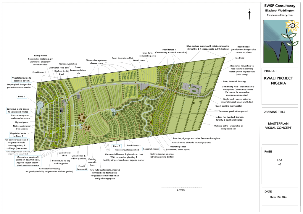
The primary goal of the Kwali Project is to create a productive and resilient landscape that integrates sustainable agriculture, ecological restoration, and community engagement. The design seeks to demonstrate regenerative land management practices that improve soil health, increase water retention, and support biodiversity while producing food and other valuable resources.
Key objectives of the project include:
- Capture and manage water effectively through ponds, swales, and vegetated drainage systems to reduce erosion and increase soil moisture.
- Improve soil fertility and long-term productivity using agroforestry systems, organic matter inputs, and regenerative farming practices.
- Develop diverse food production systems, including food forests, banana and plantain agroforestry, silvo-arable crop fields, and silvopasture.
- Integrate livestock systems through rotational grazing to support nutrient cycling and pasture health.
- Restore ecological function and biodiversity, particularly along drainage lines and riparian areas.
- Create spaces for community learning and engagement, including educational facilities and demonstration landscapes.
- Support local livelihoods and sustainable land use, demonstrating practical regenerative approaches that can be adapted elsewhere in the region.
Through these combined strategies, the project aims to transform the site into a productive, resilient landscape that balances ecological stewardship with agricultural productivity and community benefit.
The location is in the Guinea Savanna belt of central Nigeria, and has a tropical climate. This region forms a transition between rainforest (south) and semi-arid north, making it one of the most productive agricultural zones in West Africa.
Peak heat occurs February to April, with temperatures reaching 40-42 degrees C.. The rainy season is April to October and the dry season is November–March. Between December and February, dry desert winds bring dust, low humidity and cooler nights.
The project site consists of a gently sloping landscape of around 11.27 hectares, descending from approximately 243 metres elevation at the highest point on a hill to the west, to around 188 metres at the lowest point, towards the east of the property.
The site includes:
- upper slope areas with steeper gradients
- mid-slope agricultural land
- a seasonal watercourse at the lower boundary
- sandy soils with limited natural water retention (loamier near seasonal stream)
- scattered existing trees and evidence of previous pastoral use
Rainfall occurs seasonally, with periods of heavy rainfall followed by extended dry periods. As a result, effective water capture and soil improvement are central to the design strategy.
Water-Led Strategy & Design
The masterplan follows a water-first landscape design approach, where water management systems are the primary factor that determines the location and structure of productive land uses.
Key design principles include:
- capturing and storing rainfall high in the landscape
- slowing and spreading water across slopes
- improving soil organic matter and fertility
- integrating tree systems with crops and livestock
- protecting natural drainage lines and riparian areas
- creating opportunities for community participation and education
By addressing water management first, the design supports stable agricultural productivity while reducing erosion and improving ecosystem resilience.
Water harvesting is the primary organising structure of the landscape.
The system includes a series of ponds, contour swales, and vegetated drainage channels designed to capture rainfall, reduce runoff velocity, and increase groundwater recharge.
The water management system follows a cascading hierarchy designed to capture water high in the landscape, distribute it across slopes for infiltration, and safely convey excess water through vegetated drainage routes toward lower ponds and the seasonal stream.
The Kwali Project masterplan presents a regenerative landscape design that integrates water management, sustainable agriculture, ecological restoration, and community engagement.
By working with the natural topography and hydrology of the site, the design aims to transform the landscape into a productive and resilient system capable of supporting both local livelihoods and educational activities.
I offer remote design and consultancy for projects like this world-wide.
If you are planning a similar project, feel free to get in touch to discuss how I can help. I would be happy to arrange an online call, or follow up by email with suggested next steps.
